

STANDALONE TRAIL MAP
TRAIL INFORMATION

Details
| Status: | Open |
| Difficulty: | Intermediate |
| Uses: | Mt Biking & Hiking & Equestrian |
| Length: | 1.58 miles |
| Start: | 8,347' |
| End: | 9,664' |
| Min: | 8,347' |
| Max: | 9,704' |
| Gain: | 1,513' |
| Loss: | -199' |
| fly your trail in 3D | |
 |
Google Earth KML file
Download KML file above, open in Google Earth to see this trail in 3D! |
| don't get lost |
| GPX file (right click to download)
Download GPX file above, upload the track to your GPS or smartphone and you'll always know where you are!! |
Trailhead Forecast
Description / Access Information
Silver Lake: The trail up Silver Canyon was probably first developed to access the Fox Tail mineral prospect at pt. 9140. The Million Mine on the ridge dates back to 1910 so the trail has significant history. This not an official trail maintained by the Forest Service. It is steep and exposed in places but is generally easy to follow.
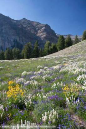
Hikers will enjoy the dramatic scenery as they pass beneath colorful and geologically complex cliffs on both sides of the canyon. In mid-July, the wildflower meadow at the mouth of the canyon is amazing, and the right fall conditions will turn the aspen grove at the trailhead a bright orange. Silver Lake is one of the few along the Boulder Front Range. Ringed by 10-and 11,000-foot peaks on all sides, it is well worth the hike in both summer and (for skiers) winter seasons.
Directions: Drive north from Ketchum to the Silver Canyon Road #174 (15.9 mi). Stay right at the first fork and wrap into a large meadow, take the right at the next junction (1.3 mi). Drive up onto the bench. 2WD cars should park at the turn, “Silver Creek #1 (2.5 mi) 4WD drive cars continue through steep, loose switchbacks(stay right) to a sloping parking area “Silver Creek #2” on the left edge of a huge aspen grove (.9 mi).
Photos
 |


